Location
Lakkos Migerou Plateau
Livadia, Rethymno
Lakkos Migerou Plateau – Livadia, Rethymno
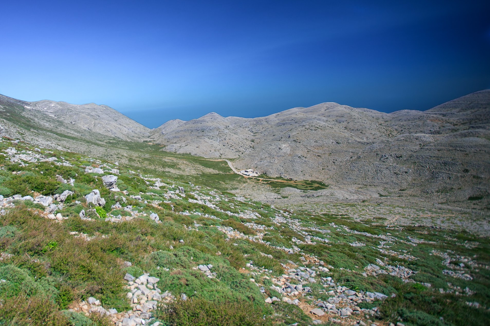
Lakkos Migerou Plateau is a high-mountain basin formed within the Psiloritis (Mount Ida) massif on Crete, situated at an elevation of approximately 1,600–1,700 meters above sea level and surrounded by dramatic valleys and karst formations. This is a place where nature reveals its raw, alpine character — snow lingers here late into the season, and the road leading to the plateau serves as a gateway to more demanding routes in Crete’s mountain ranges.
Description
Lakkos Migerou Plateau lies within the Mylopotamos region (Rethymno prefecture) and occupies the northern part of the Psiloritis massif. It is reached by an asphalt road from the village of Livadia (Λιβάδια), heading southwest, which ends at or very close to the plateau itself. The elevation is approximately 1,600–1,700 meters above sea level, with some sources giving values between about 1,580 and 1,700 meters.
The plateau itself is composed of a series of karst basins (“doline” valleys), developed parallel to a major fault–karst system in the northern section of Psiloritis.
As a result, the landscape occupies an intermediate zone between alpine pastureland and high-mountain barrenness. Linden and beech forests are absent; instead, high-altitude ecosystems dominate. Snow can persist late into the season, and the views toward both the northern and southern sides of the island are striking.
In terms of accessibility, the plateau can be reached by car. The road from Livadia is asphalted all the way to the site or very close to it.
On the plateau there is a parking area or at least a small turning space. From here, several hiking routes begin, most notably the ascent to the highest peak of Crete, Timios Stavros (Τίμιος Σταυρός, 2,456 m). The route starts from Lakkos Migerou and follows the “Strata tou Psiloriti” (Στράτα του Ψηλορείτη), a historic, stony mountain path.
In practice, the significance of Lakkos Migerou for visitors and researchers is multifaceted. It serves as a starting point for demanding mountain routes, both in terms of distance, elevation gain, and rapidly changing conditions. It is also an area of geological and geomorphological interest, featuring pastoral basins, fault-related fissures, extensive snowfields, and karst formations. High-altitude pastoralism is still present to some extent, with seasonal sheep grazing continuing in the area. Compared to Crete’s popular gorges and beaches, this is a far less crowded high-mountain setting, offering a rare sense of silence and rawness.
It is important to note that despite the asphalt access, the area should not be considered “easy” or recreational in a casual sense. The altitude of nearly 1,700 meters, exposure to strong sun or wind, and the lack of tourist infrastructure (aside from a shelter or small refuge) all require proper preparation. Sources indicate that the route from the plateau to the summit of Timios Stavros is about 9.5 km long and may take 5–6 hours to ascend, with an elevation gain of roughly 800 meters.
In summary, Lakkos Migerou is a gateway location — a threshold to the mountain world of Psiloritis, where the landscape changes abruptly, from village roads and asphalt to snowy high-altitude basins. For those seeking lesser-known paths of Crete or planning scientific exploration of vegetation, geology, or the history of pastoral life, it is a highly valuable point of departure.
Location
Livadia, Rethymno
Coordinates: 35.24127, 24.77934